AI model for clearing needs was demonstrated at IUFRO
Decision support
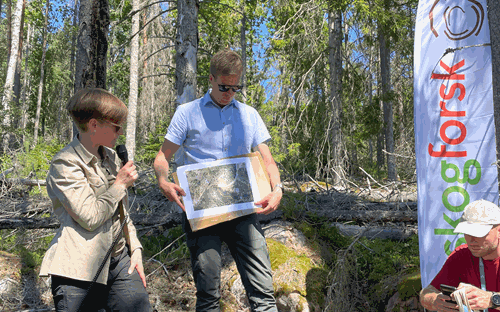
In 2024, when more than 4,000 researchers from all over the world visited Stockholm and the world's largest forestry congress, IUFRO, Mistra Digital Forest and others invited them on an excursion. Among the things demonstrated out in the forest, was an AI model that can estimate the need for clearing, using remote sensing data.
There was great interest when Mistra Digital Forest, together with the Swedish Forest Agency and SLU, invited participants at IUFRO's forestry congress in Stockholm on an excursion. Skogforsk were among those on site in the forest to demonstrate the AI model RöjSAT, which estimates clearing needs. The 200 or so participants were able to observe two adjacent stands, both of which had been analysed with the model.
– As with previous tests, this qualitative evaluation confirms that the model can assess the clearing needs in a stand, and detect local variations within it. The fact that visitors could compare the model's analysis with what they saw on site added an extra dimension, says Maria Nordström, Program Manager, digital transformation and forest planning at Skogforsk.
To be further developed within Mistra Digital Forest
The basic model has been developed by Skogforsk together with Örebro University, Field Sweden, Sveaskog, Södra and Mellanskog, with financial support from Vinnova. The forestry sector's great interest in services and support that estimates clearing needs, means that it is currently continuing its journey from a basic concept to a usable solution, within Mistra Digital Forest.
– Mistra Digital Forest is an excellent collaboration platform for companies in the forest sector and this setting suits our future development work very well, says Maria Nordström.


The first picture shows 2021 and the second 2023.
For the field trip, the AI model analysed two stands, the upper left and lower right areas in each image, separated by a road. The lower stand was thinned in 2022 and here the AI model had to analyse data from the year before the clearing and the year after, in order to see if it detected differences in clearing needs. The images show clear differences: the greener the pixels, the greater the need for clearing. The upper stand is a forest that will not be thinned for another few years.
The model was trained on satellite data, digital terrain models and specially collected positions from clearance workers. The time spent by the clearing worker in each pixel, an area of 10x10 metres, was used as an indicator of the clearing needs.