
New insights improve digital pre commercial thinning analysis
Decision support
At Skogforsk, a model is being developed that estimates pre commercial thinning (PCT) requirements on a large scale, using open-access satellite data. Up until now, the main challenge has been the lack of accuracy of the analysis. However, researchers have now succeeded in understanding why this is the case, and are able to take the next step towards a practical decision-support tool.

The forest industry has long been calling for an effective and reliable decision-support tool in order to identify PCT requirements. In response to this, for several years Skogforsk has been developing a digital solution that estimates PCT requirements on a large scale, with the help of satellite data. When Mistra Digital Forest came on board as a co-funding partner in the project, the researchers had already produced an initial model. This showed that the potential was there, but it also highlighted the obstacles that would have to be overcome. The model was able to capture patterns of both short and long PCT times, but the difference between predicted and actual PCT time was still significant. PCT time was calculated at the pixel level, meaning the length of time it took to thin a pixel that in reality corresponds to an area of 10 x 10 metres.
– We needed to understand the reasons for the difference, so we broke down the entire chain of analysis. Our initial assumption was that the error lay in the model, but it has now become clear that the quality of the reference data itself is at fault. This is an important, but not entirely surprising insight, as the forecasting of clearing requirements is complex. It is difficult to define exactly which reference data best captures the actual clearing requirements, and a consistent manner of collection on a large scale, says Alva Ringi, a civil engineer at Skogforsk.
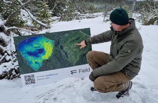
Image from the field demonstration of the model. Photo: Skogforsk.
Differing working methods make it difficult to compare data
The reference data on which the analysis is based was collected just over five years ago with the help of PCT workers in the stands managed by Södra, Mellanskog and Sveaskog. During the PCT work, they were provided with mobile phones that recorded GNSS points, with time stamps. These could then be interpreted as the time it took to thin areas of 10x10 metres, which corresponds to a single pixel on the satellite images.
– One challenge associated with the reference data collected was the variation in working methods. Some teams divided the area between them, whilst others moved around more freely, which affected the time taken. This means the data is not entirely comparable between the clearing teams, and the model risks being misleading, says Alva Ringi.
Another important insight was that the polygon – the boundary outline for the planned clearing – did not correspond to the area that was subsequently cleared. It is unclear why this was the case. However, the solution has proved to be to train the model on the areas that are actually cleared, rather than on the polygon’s boundary outline. A further insight is how important it is to have a strict separation of data. The pixels in the satellite images from the same clearing site are likely to be more similar to one another, than to pixels from completely different areas. To avoid the evaluation becoming unrealistically good, the data needs to be kept more strictly separated, so that the model is not trained and evaluated on data from the same site.
Eager to find a solution
Skogforsk now plans to continue working on the model based on this new knowledge, and new funding opportunities and new ways forward are being sought. In the future, the collection of new field data would be of interest. This is the view of Sveaskog’s technical specialist, and project partner, Marcus Abrahamsson Månsson who believes that a decision-support tool for PCT plays a vital role in improving the allocation of resources.
– At present, we lack a sufficiently robust method for estimating PCT requirements across larger geographical areas, such as at the regional level, and we are keen to find a solution. Analyses at a comprehensive level would help us set better priorities, but in order to take the next step we need to collect new data. With an ever-widening commitment from forestry companies, there is good potential for further developing the method, says Marcus Abrahamsson Månsson.